Skip to content

GISforThought

GIS and Mapping Blog from Ireland

  • Home
  • About Me
  • Post Archive
  • Portfolio
GISforThought

Glasgow CAG High Density Areas

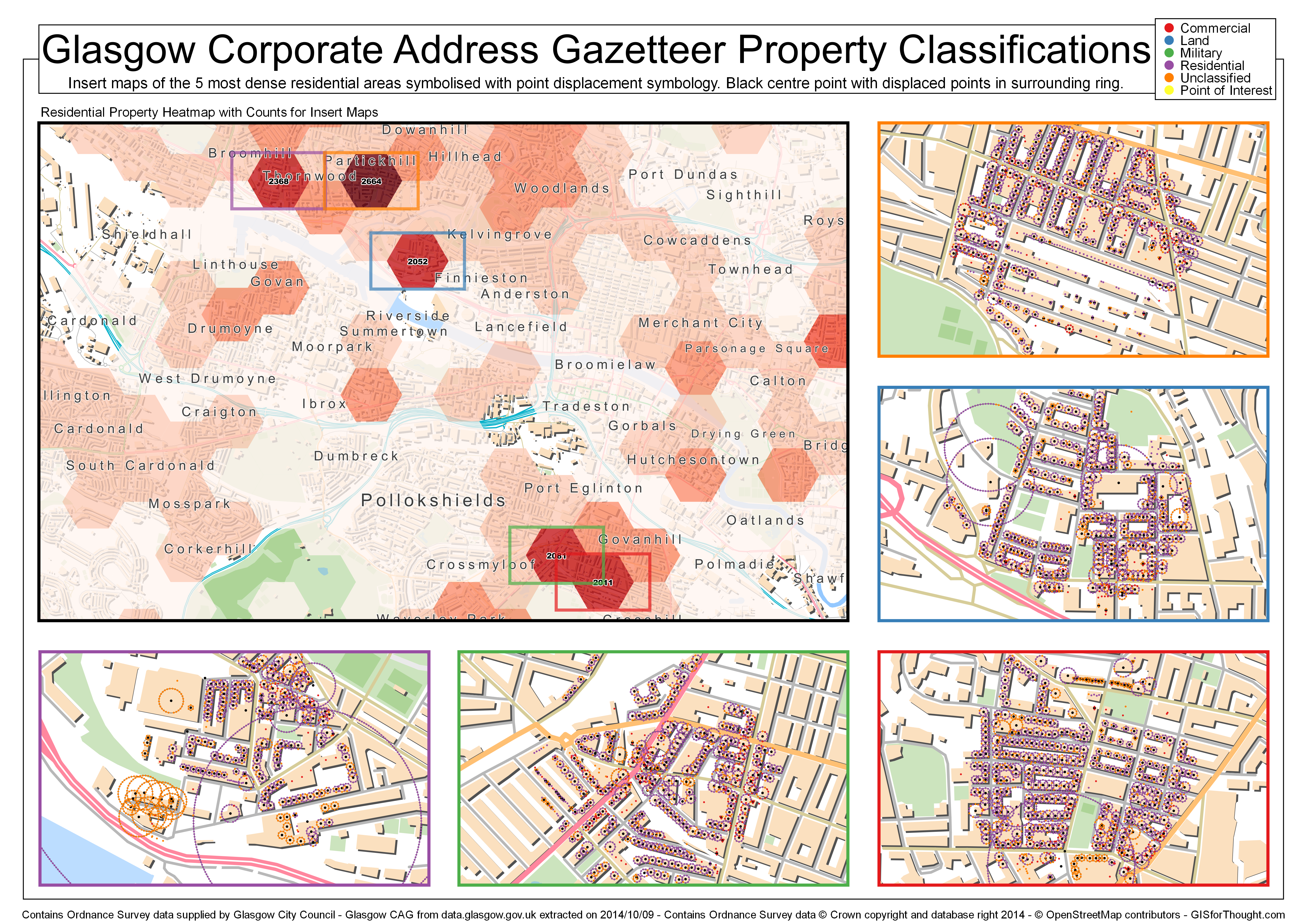
Example of the new multiple overview feature in QGIS 2.6. Point displacement, but not amazing with the zoom levels and number of points used.

Primarily looking at spacing and composition in QGIS.

Glasgow CAG

Author Heikki VesantoPosted on November 15, 2014July 27, 2022Categories All, Mapvember, OSGEO, QGIS, Scotland

Post navigation

Previous Previous post: Polygon Outlines in QGIS
Next Next post: Open UK Postcode Polygons

Post Archive

Latest Posts

  • Irish Rural Road Speed ChangesMay 27, 2025
  • Storm Éowyn ImpactFebruary 7, 2025
  • My Strava Activities from the Same Place at the Same Time AnimatedSeptember 20, 2022
  • Luas Map Compared to Real GeographyAugust 22, 2022
  • Scotland’s Cartographic OutlineAugust 9, 2022
  • Made With OpenStreetMapAugust 8, 2022
  • Featured PostsJuly 21, 2022
  • Commuting in Ireland MappedJanuary 19, 2022
  • Dublin Neighborhoods MappedJanuary 15, 2022
  • 30 Day Map Challenge 2021November 30, 2021

Featured Posts

  • Storm Éowyn ImpactFebruary 7, 2025
  • Luas Map Compared to Real GeographyAugust 22, 2022
  • Dublin Neighborhoods MappedJanuary 15, 2022
  • 30 Day Map Challenge 2021November 30, 2021
  • 30 Day Map Challenge 2019February 24, 2020
  • Every Person in Great Britain MappedMarch 5, 2019
  • Storm Harvey QGIS Geometry GeneratorSeptember 6, 2017
  • Schiehallion – Contour lines and Maskelyne’s observatoryJune 2, 2015

Categories

  • 30 Day Map Challenge (2)
  • All (97)
  • Animations (12)
  • Featured (8)
  • Finland (3)
  • Ireland (15)
  • Maps (19)
  • Mapvember (30)
  • OpenStreetMap (6)
  • OSGEO (51)
    • Leaflet (5)
    • PostGIS (15)
    • QGIS (39)
  • Scotland (33)
  • Travel (6)
  • Tutorials (12)

Popular Posts

  • Home
  • About Me
  • Post Archive
  • Portfolio
GISforThought Proudly powered by WordPress