Skip to content

GISforThought

GIS and Mapping Blog from Ireland

  • Home
  • About Me
  • Post Archive
  • Portfolio
GISforThought

Scottish Independence Referendum 2014 – Cartogram

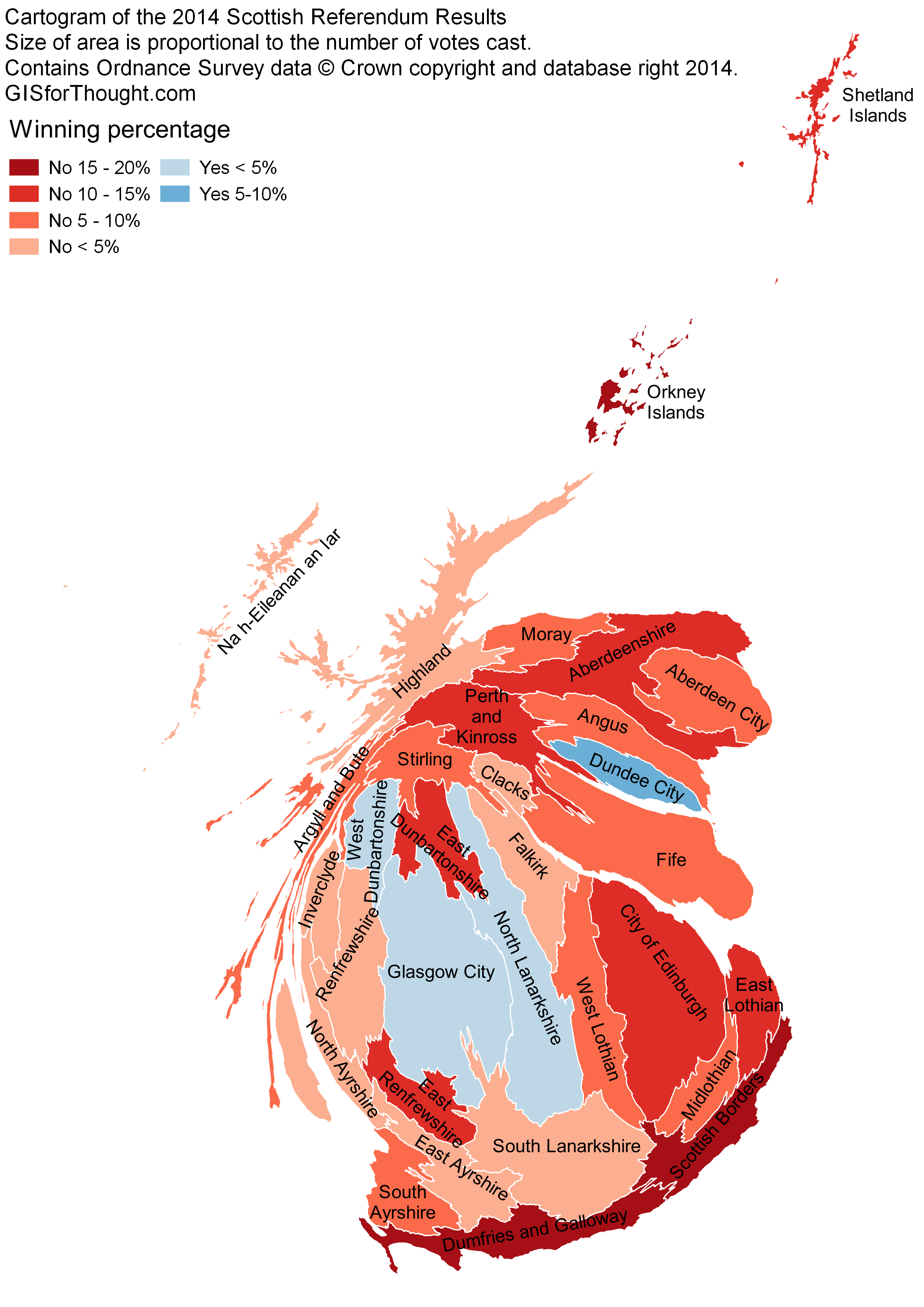
Cartogram of the Scottish Independence Referendum 2014 results. The size of an area is proportional to the number of votes cast in the area.

Made using Scapetoad and QGIS.

Scottish Independence Referendum 2014 - Cartogram

Author Heikki VesantoPosted on November 1, 2014July 27, 2022Categories All, Mapvember, OSGEO, QGIS

Post navigation

Previous Previous post: Scottish Independence Referendum 2014, Election Maps in QGIS
Next Next post: Mapping With WMS – SNH – John Muir Way

Post Archive

Latest Posts

  • Storm Éowyn ImpactFebruary 7, 2025
  • My Strava Activities from the Same Place at the Same Time AnimatedSeptember 20, 2022
  • Luas Map Compared to Real GeographyAugust 22, 2022
  • Scotland’s Cartographic OutlineAugust 9, 2022
  • Made With OpenStreetMapAugust 8, 2022
  • Featured PostsJuly 21, 2022
  • Commuting in Ireland MappedJanuary 19, 2022
  • Dublin Neighborhoods MappedJanuary 15, 2022
  • 30 Day Map Challenge 2021November 30, 2021
  • 30 Day Map Challenge 2019February 24, 2020

Featured Posts

  • Storm Éowyn ImpactFebruary 7, 2025
  • Luas Map Compared to Real GeographyAugust 22, 2022
  • Dublin Neighborhoods MappedJanuary 15, 2022
  • 30 Day Map Challenge 2021November 30, 2021
  • 30 Day Map Challenge 2019February 24, 2020
  • Every Person in Great Britain MappedMarch 5, 2019
  • Storm Harvey QGIS Geometry GeneratorSeptember 6, 2017
  • Schiehallion – Contour lines and Maskelyne’s observatoryJune 2, 2015

Categories

  • 30 Day Map Challenge (2)
  • All (96)
  • Animations (12)
  • Featured (8)
  • Finland (3)
  • Ireland (14)
  • Maps (18)
  • Mapvember (30)
  • OpenStreetMap (6)
  • OSGEO (50)
    • Leaflet (4)
    • PostGIS (15)
    • QGIS (39)
  • Scotland (33)
  • Travel (6)
  • Tutorials (12)

Popular Posts

  • Home
  • About Me
  • Post Archive
  • Portfolio
GISforThought Proudly powered by WordPress